Alexandra Innanen is an Undergraduate Researcher working at PVL for the summer. Along with MSc Giang Nguyen, they've been scouring the Northern Polar Cap of Mars in images, looking at the fine details and trying to deconvolve what role the atmosphere plays in their formation. Along the way, Alexandra has seen more than just thousands of images of dust and ice and had the opportunity (below) to talk a little bit about the aesthetic appreciation of the landscape that one can obtain from orbit. Today she shares with you her top five selections!
By Alexandra Innanen
The North Pole of Mars is a pretty cool place – pun
absolutely intended. This summer I’ve joined Giang in looking for patterns in
the Martian ice cap, something he talked about in a
previous post. I have looked through a truly astronomical number of HiRISE
images, nearly 1000 at this point. While many of them do showcase those
beautiful patterns we’re looking for (I have been known to punch the air at a
particularly uniform set of dunes), a number are what I lovingly refer to as
‘garbage’. Some of these are just flat nothingness, with no distinguishing
features to recommend it. Some are more visually interesting, but without any
sense or uniformity. These are fairly useless in terms of patterns, but can be
fun to look at, and sometimes have neat stories behind them.
I have a folder on my laptop called “Space Stuff” which I could easily rename “Nifty Pictures of Mars” at this point. It’s full of HiRISE images that I looked at and went “well, there’s no pattern there but boy is that cool!” I’m going to show off my top five images here.
Okay, the one at the top of this article is probably the coolest. Should I have ended
with it? Is everyone going to leave now? Anyway, this is an avalanche
at the edge of the layered deposits of the north pole, which fall off in steep
cliffs (reminding me a bit of the Scarborough Bluffs
near where I live). You can see the layering in the escarpment, and the edge of
the ice in the lower left corner. Here’s some perspective: the dust cloud you
can see is about 200 m across. That’s nearly two football fields long. This led
me to another image
taken in 2008 showing FOUR avalanches, which readers are encouraged to peruse
at their leisure.
Colours are exciting! The RGB colouring in this is
especially stunning, the blue ice contrasting with the bright red terrain. This shows a crater
near the Olympia Planum. Most of the ice has gone from the surroundings, but
the patch in the crater is still really bright, as it’s shielded by the crater
walls. This also plays some fun perspective tricks: the crater might appear as
though it’s above the surroundings, but it is in fact sunken into the terrain. Craters
like this are used to estimate the age of the landscape; a younger landscape
will have fewer craters whereas an older one will have more. However, surface looks can be deceiving. Based on the
number of craters around the pole, the ice cap could be around 100 000 years
old, a relative baby in geological terms. Yet because the surface is constantly reshaped by ice, the oldest craters get destroyed.
Here
is another boundary (what geologists would call a contact) between the layered deposits of the ice cap and the
surroundings. You can really see all the different layers in here, and the
boundary between the ice and the surrounding terrain is incredibly clear. This
was taken in the Martian spring, when most of the ground is still covered in
frost (carbon dioxide, not water). Also hidden in this image are some avalanche
deposits. In fact, this is the same region as the image with four avalanches
that I mentioned earlier, this image being taken just over two years later.
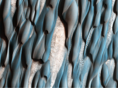
While there is something to be said for lovely, uniform
dunes, the ones above are certainly more exciting to look at. These are some dunes
in a region known as Abalos Undae, tucked between two chasms to the west of the
Chasma Boreale. This is an enhanced colour image, and the different colours
show differences in composition. The blue indicates the basaltic nature of the
dunes, while the more creamy-reddish areas are likely dust. Looking closer you
can see grooves and ripples carved into the dunes by winds. It has been
suggested that the dunes are no longer migrating, and that these smaller
features are the only ones remaining active here. Though dunes do move elsewhere on Mars.
You don’t have to have colour to make a striking image, as this one above
clearly demonstrates. The nearly perfectly circular edge led me first to
believe that this was another crater, but it is in fact another escarpment
dropping off from the ice cap. Again, the layering is very clear in the scarp –
the brighter white area – and there is a vast difference between the relative
uniformity of the ice cap, lower in the image, and the terrain at the bottom of
the scarp (confusingly situated at the top of the image). This is one of a
number of regions that are being monitored for avalanches.
There are so many more fascinating images I could share,
just of the Martain north pole, but that would probably devolve into a lot of
exclamation marks and excited capital letters. So I’ll leave a link to the HiRISE special releases page.
There’s some really neat stuff there, and it is well worth anyone’s while to
check out.


No comments:
Post a Comment